Chari-Baguirmi (prefecture)
Appearance
This article needs additional citations for verification. (December 2009) |
| Chari-Baguirmi Prefecture Préfecture du Chari-Baguirmi محافظة شاري باقرمي | |||||||||||||
|---|---|---|---|---|---|---|---|---|---|---|---|---|---|
| Prefecture of Chad | |||||||||||||
| 1960–1999 | |||||||||||||
 | |||||||||||||
| Capital | Fort-Lamy (1960–1973) N'Djamena (1973–1999) | ||||||||||||
| Area | |||||||||||||
| • Coordinates | 12°06′N 15°2′E / 12.100°N 15.033°E | ||||||||||||
• 1960 | 100,000 km2 (39,000 sq mi) | ||||||||||||
• 1993 | 82,910 km2 (32,010 sq mi) | ||||||||||||
| Population | |||||||||||||
• 1960 | 300,043 | ||||||||||||
• 1993 | 720,941 | ||||||||||||
| • Type | Prefecture | ||||||||||||
| Historical era | Cold War | ||||||||||||
• Established[1] | 13 February 1960 | ||||||||||||
• Disestablished[1] | 1 September 1999 | ||||||||||||
| Political subdivisions | Sub-prefectures (1993)[2]
| ||||||||||||
| |||||||||||||
| Area and population source:[1] | |||||||||||||
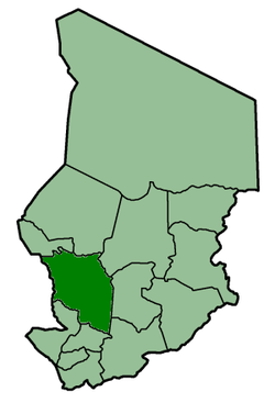
Chari-Baguirmi was one of the 14 prefectures of Chad. This was before Chad's further reorganisation in 2002 into 18 regions and an even further division as of 2024, into 23 provinces. Located in the west of the country, Chari-Baguirmi prefecture covered an area of 82,910 square kilometers and had a population of 720,941 in 1993. Its capital was Ndjamena.
See also
[edit]References
[edit]- ^ a b c "Administrative Divisions of Countries: Regions of Chad". www.statoids.com.
- ^ "Administrative Divisions of Countries: Departments of Chad". www.statoids.com.
| |||
|
Batha · Biltine · Borkou-Ennedi-Tibesti · Chari-Baguirmi · Guéra · Kanem · Lac · Logone Occidental · Logone Oriental · Mayo-Kébbi · Moyen-Chari · Ouaddaï · Salamat · Tandjilé · | |||
|
See also : Regions of Chad - Departments of Chad |

